Steve's World Blog Information and articles on cities, towns and villages around the world.

November 22, 2010

Ampleforth North Yorkshire

Filed under: England,Travel,United Kingdom — Tags: , , , , — needahand @ 11:57 am

Situated in the Ryedale district of North Yorkshire, the small village of Ampleforth stands on the southern fringes of the North Yorks Moors National Park, and is a perfect base for touring this area of great natural beauty. With its population of 888, Ampleforth is only a tiny village, though it has some history, and its parish church dates from Saxon times, it also has a abbey (Ampleforth Abbey), which is located about a mile from the village centre.  Ampleforth is about 20 miles drive from the city of York, and nearby places include, Yearsley, Grimstone and Fritton, head into the North Yorks Moors, and you will find the hamlets of Wass and Oldstead .

See a map of Ampleforth here: http://www.my-towns.co.uk/ampleforth-map.html

And a map of the North Yorks Moors here: http://www.my-towns.co.uk/north-yorks-moors-map.html
November 15, 2010

Skipton North Yorkshire

Filed under: England,Travel,United Kingdom — Tags: , , , — needahand @ 10:13 am

A market town located in the Craven district of North Yorkshire, Skipton is often referred to as “The Gateway to the Dales”, due to its position at the southern tip of the Yorkshire Dales, an area of great natural beauty. Dominated by its medieval castle, which was originally built by the Normans, Skipton has a number of interesting places to visit including the George Leatt Industrial and Folk Museum, the Craven Museum, and the High Corn Mill, a restored mill building. When the weather is pleasant be sure to take a stroll along the towpath of the Leeds and Liverpool Canal, which runs through the town. Skipton is approximately 27 miles from Leeds.

See a map of Skipton here: http://www.my-towns.co.uk/skipton-map.html

And the latest Skipton weather here: http://www.my-towns.co.uk/skipton-weather.html

November 11, 2010

Hertford Hertfordshire

Filed under: England,History,Travel,United Kingdom — Tags: , — needahand @ 4:59 pm

A town and parish located in the county of Hertfordshire, England, Hertford has a population of around 24,000 and a history going back to Anglo-Saxon times, when it acquired its name which no doubt refers to its position on a ford over the River Lea, where harts (or stags) would have crossed. First recorded as a town in 673, Hertford was a significant town by the time of the Norman conquest, having mills, churches and markets already established. The Normans built a castle in the town and there was also a priory erected, which remained until the dissolution of the monasteries in the 16th century. Hertford grew prosperous over the centuries and especially after the arrival of a canal in 1767 and the railway in the mid-nineteenth century. Hertford has been the county town of Hertfordshire since Saxon times, and has retained its importance in the affairs of the county. Major landmarks in the town include Hertford Castle, with some original sections, the Robert Adam designed Shire Hall (1779), Wallace House, the Corn Exchange and the Hertford Museum. Hertford lies at the confluence of four rivers, them main one being the River Lea, and when the weather is fine there can be no better way to spend a few hours than to take a stroll along the river, or even hire a boat and cruise along the river itself.

November 10, 2010

Moraira Costa Blanca

Filed under: Costa Blanca,Holidays,Spain,Travel — Tags: , — needahand @ 1:49 pm
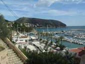
Moraira Port and Marina

Moraira Port and Marina

An attractive town on the northern Costa Blanca, Spain, Moraira is located just a few miles from Javea. Up to around forty years ago Moraira was little more than a few fishermens cottages, sitting along the sea front. Although a marina and a number of urbanizations have since been built, the town has still retained much of its original quaint charm, most of the property in the area comprises isolated detached villas set amongst trees and vegetation. The beaches of Moraira have decent sand and warm, clear water, and are the ideal place to enjoy the wonderful Moraira weather, which is mostly sunny and dry throughout the year. The main beach of Moraira, Playa de L’ Ampolla, is within easy walking distance of Moraira’s town centre but it can get very busy during the summer season. A little to the south is the excellent beach of the Platgetes which is lined by a promenade. There are several pretty bays along the coast around Moraira, some of which are very rocky, making them perfect for snorkeling or diving. One of the finest coves is the Cala Punta Estrella, which can be accessed via steps dug into the cliff face. The pretty marina which is located close to the town centre and has over six hundred berths. Moraira is a desirable location for the purchase of holiday property and has also seen many expats settle permanently in the resort over the last 30 years or so.

Moraira Street Map.

November 8, 2010

Barnsley South Yorkshire

A town located to the north of Sheffield in South Yorkshire, Barnsley lies on the River Dearne and has a population of about 218,000. A centre for Yorkshire coal mining industry, Barnsley has also been notable for glassmaking. Originally a Saxon settlement, it had a population of 200 when listed in the Domesday Book of 1086. A busy market town for many centuries Barnsley received its charter to hold a market way back in 1249, its market was held on Wednesdays, the town also held 3 annual fairs, which attracted people from miles around to the town. Barnsley mostly grew to its present size due to the Industrial Revolution, when coal mining and glassmaking were important industries. Nearby places to visit include Wakefield (see map), the aforementioned Sheffield (see map), Huddersfield, Doncaster and Mexborough (see map), the northern areas of the Peak District National Park are also nearby.

View a map of Barnsley here: http://www.my-towns.co.uk/barnsley-map.html

November 7, 2010

Southend on Sea Essex

Filed under: England,Travel,United Kingdom — Tags: , , , , , — needahand @ 9:07 am

A large seaside resort and working town located on the Thames Estuary in Essex, Southend-on-Sea has been a popular resort since the early 19th century. Originally just a group of fishermen’s cottages at the southern end (south end) of the ancient village of Prittlewell, the town now takes in some 7 miles of coastline, pretty much swallowing up the areas of Westcliff, Prittlewell and Leigh-on-Sea, and has a population of around 165,000. Famous for its pier, which at one and a third miles long, is the world’s longest, Southend reached its zenith in the 1960’s and 1970’s, when it was particularly popular as a day tripper resort. The beach which can get quite busy when the weather is fine, is a mixture of shingle and sand , with a good helping of mud thrown in, due to its estuary location. As well as the beach and pier, Southend also has plenty of green areas, with over 1,000 acres of parks and gardens.

Map of Essex.

« Newer PostsOlder Posts »

Powered by WordPress